A poor summer month - cool and unsettled
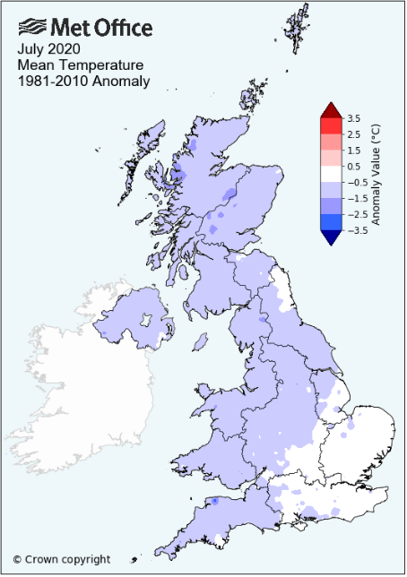
Apart from recording the third equal warmest day in my records, July was an unremarkable month that often disappointed. It certainly could not have been described as a summer month as it was often cool and cloudy, actually quite dull at times and there certainly wasn't any hint of any lasting warm spell.
Only five days managed to attain the seasonal average of 19.6°c with the mean maximum temperature for the month markedly below average, although there was also some cool nights as well.
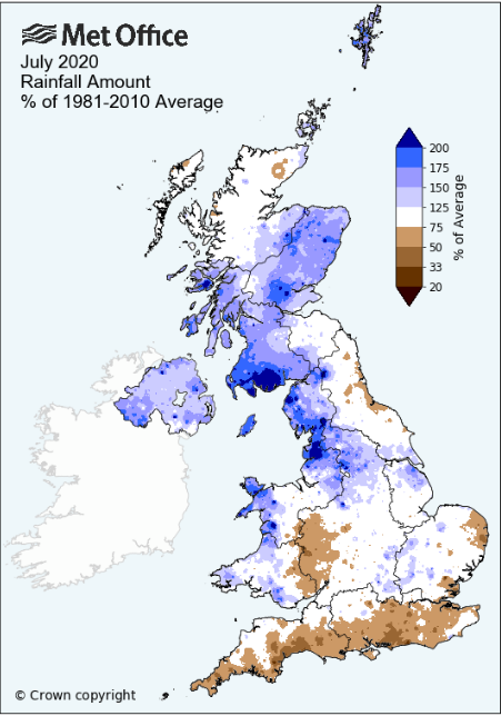
Rainfall came frequently, albeit not heavily. However, whilst the final total fell below my 13 year average, totals across the county were above the 30 year long term average. This poor weather came courtesy of frequent low pressure systems arriving from off the Atlantic with high pressure never managing to become established
At the end of the month an area of low pressure in the Atlantic drew warm air up from the continent which provided for one very warm day on the 31st.
MSLP of 1014.0 Mb was -0.4 Mb below the local average for the month and overall a mean minimum of 10.01°c and a mean maximum of 17.89°c saw the temperature 1.12°c below the eleven year average for this site.
It was the coldest since 2012 and of the twelve now recorded, two have been colder and nine have been warmer - the highest maximum temperature recorded being 29.5°c (31st), the lowest minimum 5.7°c (20th).
Rainfall of 87.5 mm (Castlehowe Scar 116.8 mm) was 85.5% of average for 2007-19 and made it the driest July since 2018. Of the fourteen now recorded, five have been drier and eight wetter.
In what was a fairly quiet month, there were no 'Days of' although it has been the windiest July yet recorded here - the wind speed averaged 8.52 mph, with a maximum gust of 42 mph (3rd).
At the Met' Office site at Newton Rigg a mean temperature of 14.20°c is the coldest since 2017 and in a series back to 1951, (with one year of no data) 24 have been colder, 43 have been warmer, with one year having the same mean temperature.
The rain gauge broke down at the beginning of the month and awaits repair.
At Seathwaite Farm it was the wettest since 2010 and its sixth wettest in a record that commenced in 1845.
Rainfall totals across Cumbria were above average, typically in the range of 120-150% of normal, but at Seathwaite it was as high as 236.5% with an inch or more of rain having fallen on seven days.
Figures from the Environment Agency’s rainfall sites were, (figure in brackets being the monthly average for 1961-90) ‘Data kindly provided by the Hydrometry and Telemetry team of the Environment Agency (Penrith)’:
Kirkby Thore ** mm (42.2 mm)
Haresceugh Castle (Kirkoswald) 95.77 mm (78.2 mm)
Brothers Water 213.7 mm (142 mm) and
Orton (Shallowford) ** mm (97.9 mm [average for 1967-2019])
482.4 mm at Seathwaite Farm (Borrowdale - 204 mm [average for 1981-2010]).
** not available due to faults with the gauge
General Synoptic Report for the Month
The month opened with frontal systems over the UK and low pressure (LP) to the fore. Subsequently the days were rather cool and it was breezy at times with spells of rain, although under a cover of cloud, temperatures remained high overnight. Rainfall totals weren't especially high, 9.3 mm on the 5th being the highest in this period, but which at just 14.6°c was chilly.
High pressure (HP) in the Atlantic tried to ridge in 6-7th and whilst the days were dry, they remained cloudy and the 7th was another decidedly chilly day, in fact the month's coldest day at just 14.0°c.
LP then returned to southern England 8-9th with Cumbria at its northern edge. Rain arrived at tea-time 8th and stayed overnight, repeated the following day with 10.7 mm of rain (9th).
Through the 10-16th HP gained a weak foothold on the UK, albeit the 13th saw a frontal system pass over the UK and after which the HP never fully exerted any meaningful control. Whilst rainfall was almost absent it still tended to be somewhat cloudy with temperatures remaining below average. However, the final day of the period, 16th, did see the temperature rise to 20.4°c, the first day of the month to do reach 20°c.
LP over Iceland dominated the next few days before HP in the Atlantic started to nudge in. Rainfall totals were insignificant despite several fronts passing over and when the HP began to move in it initially brought a NW'ly flow before backing W'ly.
In spite of a little sunshine, this cool airflow felt very fresh and kept a lid on the temperatures, both the 19-20th were cool overnight, down to 5.8°c and 5.7°c respectively and at just over 16°c during the day it certainly didn't feel anything like summer.
The HP would collapse come the 21st-22nd as fronts moved in from the west. The 22nd was cool and cloudy, attaining just 15.5°c followed by grey and damp conditions on the 23rd with spells of rain into the late afternoon - then the sun finally managed to pop out and the temperature 'soared' to just above 20°c.
Separate LP systems would continue the unsettled theme over the next few days. This brought spells of rain, albeit falling overnight 25th and 26th, with both having a few sunny spells later in the day; but then it would be wet on the 27th. Rain overnight into the 27th saw 12.5 mm (credited back to the 26th to make it the month's wettest day), with the rain (9.6 mm - 27th) continuing through to tea-time.
The pressure gradient then slackened with HP trying to nudge in, but whilst there were sunny spells on the 28-29th, the temperature remained suppressed, just 15.5°c on the 28th.
After rain overnight and for most of the morning, the 30th quickly improved with sunny spells developing and now the temperature did rise - LP to the west of Eire tracked north and acted to draw up a very warm southerly airflow and at 1000 hrs on the 31st it was already 23.6°c. The day was also vey sunny and saw a maximum of 29.5°c (85.1°c).
The warmth only lasted a day though as the 1st would see a drop in temperature of 11.4°c!
Rainfall totalled 87.5 mm for the month, with rain recorded on 20 days of which 16 were 'Wet days' (1.0mm +).
The Mean Temperature for the month was 13.95°c -- The Mean Max' was 17.89°c -- The Mean Min' 10.01°c.
We had 0 Air Frosts in the month (year 21) -- Grass Frosts totalled 0 (year 78).
The 1 foot soil temp ranged from a low of 15.5?°c on the 8-9th to a high of 16.8°c on the 26th -- with a monthly mean of 16.1°c
The 1 meter soil temp ranged from a low of 13.9°c on numerous dates to a high of 14.4°c on the 30th - 31st -- with a monthly mean of 14.0°c
This makes the Jan' to July period of 2020 0.56°c warmer than the average for 2009-19 and with 141.6% of average rainfall for 2008-19
JANUARY 2010
FEBRUARY 2010
MARCH 2010
APRIL 2010
MAY 2010
JUNE 2010
JULY 2010
AUGUST 2010
SEPTEMBER 2010
OCTOBER 2010
NOVEMBER 2010
DECEMBER 2010
JANUARY 2011
FEBRUARY 2011
MARCH 2011
APRIL 2011
MAY 2011
JUNE 2011
JULY 2011
AUGUST 2011
SEPTEMBER 2011
OCTOBER 2011
NOVEMBER 2011
DECEMBER 2011
JANUARY 2012
FEBRUARY 2012
MARCH 2012
APRIL 2012
MAY 2012
JUNE 2012
JULY 2012
AUGUST 2012
SEPTEMBER 2012
OCTOBER 2012
NOVEMBER 2012
DECEMBER 2012
SUMMER 2012
REVIEW OF 2012
JANUARY 2013
FEBRUARY 2013
MARCH 2013
APRIL 2013
MAY 2013
JUNE 2013
JULY 2013
AUGUST 2013
SEPTEMBER 2013
OCTOBER 2013
NOVEMBER 2013
DECEMBER 2013
REVIEW OF 2013
JANUARY 2014
FEBRUARY 2014
MARCH 2014
APRIL 2014
MAY 2014
JUNE 2014
JULY 2014
AUGUST 2014
SEPTEMBER 2014
OCTOBER 2014
NOVEMBER 2014
DECEMBER 2014
WINTER 2014
REVIEW OF 2014
JANUARY 2015
FEBRUARY 2015
MARCH 2015
APRIL 2015
MAY 2015
JUNE 2015
JULY 2015
AUGUST 2015
SEPTEMBER 2015
OCTOBER 2015
NOVEMBER 2015
DECEMBER 2015
REVIEW OF 2015
JANUARY 2016
FEBRUARY 2016
MARCH 2016
APRIL 2016
MAY 2016
JUNE 2016
JULY 2016
AUGUST 2016
SEPTEMBER 2016
OCTOBER 2016
NOVEMBER 2016
DECEMBER 2016
REVIEW OF 2016
JANUARY 2017
FEBRUARY 2017
MARCH 2017
APRIL 2017
MAY 2017
JUNE 2017
JULY 2017
AUGUST 2017
SEPTEMBER 2017
OCTOBER 2017
NOVEMBER 2017
DECEMBER 2017
REVIEW OF 2017
JANUARY 2018
FEBRUARY 2018
MARCH 2018
APRIL 2018
MAY 2018
JUNE 2018
JULY 2018
AUGUST 2018
SEPTEMBER 2018
OCTOBER 2018
NOVEMBER 2018
DECEMBER 2018
REVIEW OF 2018
JANUARY 2019
FEBRUARY 2019
MARCH 2019
APRIL 2019
MAY 2019
JUNE 2019
JULY 2019
AUGUST 2019
SEPTEMBER 2019
OCTOBER 2019
NOVEMBER 2019
DECEMBER 2019
REVIEW OF 2019
JANUARY 2020
FEBRUARY 2020
MARCH 2020
APRIL 2020
MAY 2020
JUNE 2020
OTHER ARTICLES
The Oldest Inhabitant
An Inch Of Scotch Mist
But it's meant to be Summer (Summer 2017)
© Darren Rogers 2010-20
Want to comment on this site? email